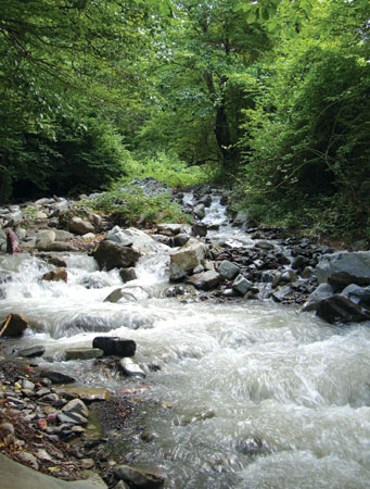
 Kilsechay river in Oghuz region
 by Zakir Eminov
The land of Azerbaijan has a natural environment which is fascinating and unique - with a touch of mystery. The miracles of nature to be experienced in its different regions never fail to attract and amaze. The complex geography, geological structures and range of natural climatic conditions further the shaping of its natural features. We will describe the wonderful features of the Azerbaijani landscape in terms of its geology and flora and fauna.
Natural geological features - Nature’s architecture
The mountain peaks and some of the variously-shaped rocks are a focus for tourists as sights to be seen in themselves and also for the panoramic views they provide. The Ilan Dag and Goyazan mountains, located in the Autonomous Republic of Nakchivan and in the Qazakh region respectively, are blister cones formed during volcanic eruptions resulting from magma penetration into rock strata; the magma hardened and weathered while the surrounding strata eroded away. Ilan Dag is a towering 2,415 metres of volcanic rock. The actual height of Goyazan is 858 metres, compared with its surroundings at 250 metres. They both have prominent shapes, clearly seen from the low-lying lands that surround them.
Besh Barmaq Rock also juts up considerably higher than its surroundings. The rocks are polished and stand atop steep hillsides. The steep Alti Agach rocks in the Khizi region are fossil rocks (limestone). They are the remains of reefs, strangely altered from their original shape. There are pentagonal and hexagonal prisms and columns up to 40 metres high, formed from basalt rocks in the Kalbajar district. Geologically, they are column-shaped basaltic partings.
The mountain of “Baku storey” and the Boyukdag mountain clays are also striking geological features. The anthropogenous sediment rock stratum generates the layer of 70 metre depth on the mountain of “Baku storey”.
Also related to this group are the classic section of the Kushkuna-Aghjagil marine sediments in the Jeyranchol area of the Agstafa region, a strange, bird-shaped formation created by weathering and solar radiation in Guzdek village and the Ateshgah geological area, located in the same region. Maykop clay developed a distinctive shape when entering the younger rock layers of the latter area.
The mountains called the “ears” of Baku are located near the Korgoz settlement in Absheron district. They were formed as an anticlinal fold in solid fossil rocks from the medieval Absheron period. The “ears” of Baku, or Mount Garadagh-Karkas, is a hill with two peaks. Sailors used this landmark as a lighthouse because it is the highest point on Absheron. The Karkas rocks have been eroded and planed by physical weathering and wind erosion and strange human and animal-like shapes have been created in the rocks.
Valleys, monuments of nature
The flows of mountain rivers have, over millions of years, created special valleys. Sometimes, when soft rocks generate thick layers, deep, narrow river valleys are the result. One example is the Tanga valley formed on the Tanga River - a tributary of the Valvala River in the north-east of the Great Caucasus. This valley is some 400-600 metres deep.
A slope of rocks ranging from the Palaeozoic era to the anthropogenic period of the Cainozoic Era can be seen in the Nehram valley located in the Julfa district of the AR of Nakhchivan. The Yasamal valley in Absheron is also a very particular landscape. As the Garamaryam ridge in the south of the Great Caucasus is perpendicular to the Girdimanchay valley, the river crosses it transversely in five places. The ridge is 25 km long, 6 km wide and 350-500 metres high. The valleys created by the river are called “Padar penjereleri” (Windows of Padar) or “Padar Darvazalari” (Gates of Padar).
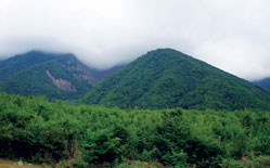
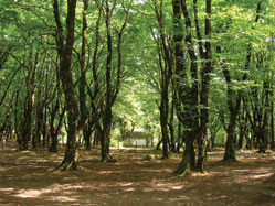
 Alti Agach forest
 In mountainous areas of limestone rock, the distinctive topography of karst landscapes appear. Caves are particularly characteristic here. The Azykh cave is hugely significant historically, culturally and archaeologically. It is situated in Khojavand district in an area of chalky rock from the Jurassic period. The cave has six chambers and is 250 m long and 20 m high. This is the site of one of the most ancient human habitats. Human traces and samples of culture belonging to the Palaeolithic period have been found here.
The following caves are protected as natural monuments in Azerbaijan: Taghlar (length 22 metres) in Khojavand district; Khan (length 114 metres) and Gahal (length 72 metres) in Shusha district; Garainek (length 30 metres) in Dashkesen district; the cave of the same name (length 48 metres) in Kilit village in Ordubad district, the AR of Nakhchivan; Divler Sarayi (Ogres’ Palace) (length 30 metres) in Daghtumas village, Jabrayil district; Galahalti (length 50 metres) in Shabran district; Avey (length 73 metres) in Dash Salahli village in Gazakh district and the cave of the same name (length 40 metres) in Hashi village in Guba distirct.
The Keshikchidagh caves complex in Agstafa district boasts a unique lay of the land and a particular nature. It is a site full of numerous archaeological monuments, thus it is protected as being of cultural and historical significance. Ancient people used these caves as a place of refuge. Since 19 December 2007, the caves complex covering part of the Keshikchidagh chain has been the “Keshichidagh” State Historical and Cultural Reserve.
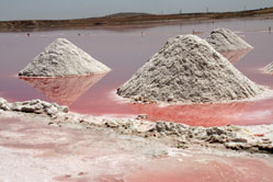
Mud volcanoes - the Earth’s hot pots
Mud volcanoes belong to the range of natural geological monuments and are spread across the Absheron peninsula, in Gobustan, in the South-eastern Shirvan plain and on the islands of the Baku archipelago. Their distribution occurs in areas of sand-clay sediment rocks and oil and gas fields in adolescent detachment areas. There is nowhere else in the world like Azerbaijan for the variety and activity of its mud volcanoes. 45 percent - more than 300 - of all the mud volcanoes registered in the world are located in Azerbaijan. Mud volcanoes create miraculous environments; most of them continuously expel hot water and melted mass (breccia). Mud from these volcanoes contains valuable chemical substances which are very important in the treatment of various diseases of the gastrointestinal tract, urology and cosmetology.
Lokbatan, Ayrantokan, Boyuk Kenizdagh and Dashgil have mud volcanoes included in the list of natural monuments. 23 mud volcanoes were included in the list of the protected natural monuments. On 15 August 2007, the State Nature Reserve was established to protect mud volcanoes and develop ecological tourism.
Eternal flames
There are many natural monuments connected with Azerbaijan’s oil and gas reserves. Yanar Dag and Ateshgah are two examples.
Yanar Dag is situated near Mammadli village in Absheron district; natural methane surfaces here and burns. Natural gas flames in the craters of most mud volcanoes; for example near Khinalig village in Guba district, the flames are the result of gas escaping from burning shale and coming to the surface. It is a fascinating sight.
Other eternal flames also exist near Surakhani village, some 20 km from Baku. The amazing fire worshippers’ temple, Ateshgah, was built there and still stands.
 Besh Barmaq (Five Finger) mountain in Siyazan district. Khizirzinda Sanctuary is on this mountain
 In Azerbaijan, rock layers containing the remains of plants and animals which inhabited the sea and the land in ancient times are protected as monuments of nature. These territories are included in the list of palaeontological monuments. The Pirekushkul fauna graveyard is near Pirekushkul village in Absheron district. Rocks full of the remains of unique sea animals are preserved here in the Maykop clay and clay shale. Remains of Cetacea, large marine mammals, fish, turtles, seals, reptiles, lobsters inhabiting the Tethys ocean, birds, including unique birds with teeth, various insects and coniferous trees from the Neogene period are to be found there.
The deposit of Eldar vertebrate fauna situated in Samukh district is also included in the palaeontological monuments. Remains of vertebrate animals from the Neogene period have accumulated here on the right bank of the river Gabirri. The asphalt (bitumen) lake situated near Binagadi district, 10-12 kilometres to the northwest of Baku, was created by oil naturally leaking to the surface and then hardening during the Pleistocene era. Later, animals died here and their remains have been preserved in comparatively satisfactory condition. This is why numerous bones - of cave bears, rhinoceroses, bulls, deer, hyena and other animals - have been found in a lake called “the asphalt graveyard”. The remains of various animals have been discovered in rocks of the Neogene and the Quarternary periods of the Cainozoic Era in the Duzdag stratotypic section situated in the Yevlakh district and within marine sediment in Absheron and Baku. The remains of ostrich eggs, elephants, horses, bulls, beavers and other animals have been found here.
Mineralogical sites
Minerals are found at sites like the Vesuvius hill, rich in reserves of vesuvianite and tourmaline crystals and the salt mine in the AR of Nakhchivan. Respiratory tract illnesses and pulmonary diseases are treated at the physical therapy centre established in the salt mine.
Lakes - the creative work of earth and water
Natural climatic conditions and the variety of Azerbaijan’s topography have created lakes with complicated hydrological features. For example, Tufan Gol (Tufan Lake) in the Great Caucasus originated from a glacier. The Lakes Boyuk and Kichik Alagol (Great and Minor Alagol Lakes) of tectonic origin and Goygol (the Blue Lake) caused by landslide appeared in the Lower Caucasus. Batabat gol (Batabat Lake) in the AR of Nakhchivan also appeared following a landslide. The fascinating and picturesque nature of these lakes creates great opportunities for the development of tourism in the region.
Tufan Gol (Tufan Lake) is actually two lakes. One belongs to the basin of the Gusar River, the other to the basin of the Damiraparan River. These lakes were created by the movement of ancient glaciers and formed when valleys were dammed by a moraine ridge. They are located at an altitude of 3300 m, in a rocky landscape. They are fed by snow and glacial waters, provide no economical benefit and are covered by thick ice in winter.
Goygol (the Blue Lake) is in the Lower Caucasus, on the northern hillsides of the Murovdagh mountain chain, at an altitude of 1553 m. The lake was formed as a result of the Agsu River being dammed by a landslide during an earthquake in 1139. Lakes Maralgol, Aghgol, Shamligol, Ordekgol, Jeyrangol and Garagol were formed at the same time. Hook-shaped pine trees of ancient origin have grown on the hillsides of the mountains around Goygol. Mountain goats, European red deer, roe deer, brown bears, foxes and partridges live in the forest.
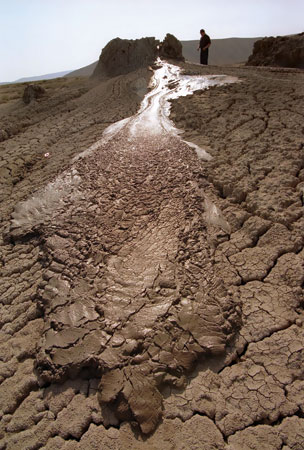 Mud volcano in Absheron district. Most of the world´s mud volcanos are in Azerbaijan
 Lakes Goygol and Maralgol and adjacent areas around Hajikend settlement are outstandingly picturesque and contain springs of mineral water. Recreation bases for local residents and tourists have been set up in these territories. On 1 April 2008, the Goygol National Park was established in order to develop ecological tourism and to exploit its potential for tourism and recreation.
Lake Boyuk Alagol is located on volcanic pasture in Karabakh, at an altitude of 2729 m. It is of tectonic origin. Volcanic activity in the Quarternary period influenced the shaping of its hollow cavity. It extends across an area of 510 hectares, it is 3670 m long and its maximum width is 2875 m; it is 9.4 m deep. There are around 30 lakes in this basin. The largest of them (90 hectares) is Lake Kichik Alagol. Its water is used on pastures.
Batabat Lake is in the Shahbuz district of the AR of Nakhchivan, in the basin of the Nakhchivan River and covers an area of 16.0 hectares. The basin is used to irrigate land in the Babek district. Its surroundings are used as pasture. The local climate and landscape are favourable for the creation of tourist and recreation facilities. The existing meadows, clean, life-giving air, natural forests and bushes, fresh water streams (Zorbulag and Sudlubulag) and mineral water springs surely demand the creation of a leisure and tourism zone. Conditions are very favourable for the treatment of cardiac diseases and diseases of the nervous system.
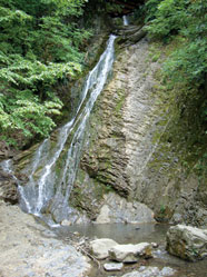
Waterfalls break through
There are numerous waterfalls on the rivers running from mountainous areas of the country. They were created when rivers pushed through severely eroded sheer hillsides. Every waterfall is unique in its height, intensity of flow, surrounding landscape and environment
Afurja on the Valvala river, Mijig on the Damiraparan river, Hamzalichay on the Hamzali river, Sariguney on the Kish river, Ilisu on the Kurmuk river and others are among the best known waterfalls in Azerbaijan. The Afurja waterfall near Afurja village in Guba district, cascades for 60 m and has been included in the natural monuments.
Mineral springs - health from the depths
The mountains and foothills of Azerbaijan are rich in mineral springs. The surfacing of these springs is a particular natural sight. The minerals (sulphur, carbon and nitrogenous gases) contained in the waters are beneficial in the treatment of gastrointestinal, cardiac, vascular, urological, skin and rheumatic diseases.
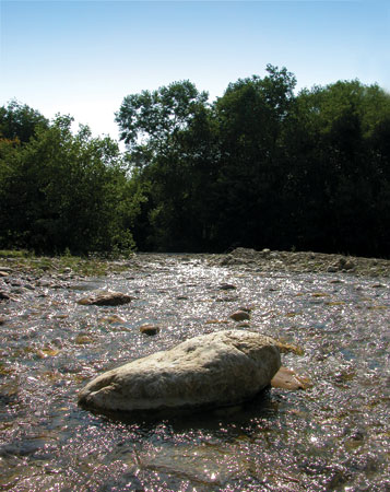 Alpanchay river, Quba region
 The Shemakha mineral springs situated on the outskirts of Chikhuryurd village and the Madrasa settlement in Shemakha district have been included in the state’s list of natural monuments. These natural water sources come to the surface as a result of the collapse of upper chalk sediments onto Neogene rocks.
Azerbaijan could well be considered a land of natural monuments. These monuments could be highly significant for the development of medical treatment, leisure and tourism.
About the author: Zakir Eminov is a Doctor of Philosophy in economic science, an associate professor and leading scientist in the department of “Population geography and social development in Azerbaijan” at the NASA (National Academy of Sciences of Azerbaijan) Institute of Geography.
Literature
1. B.A.Budagov. Natural monuments of Azerbaijan. Baku, 1990
2. Z. N.Eminov. Geography. Baku, 2005
3. H.A.Aliyev, K.H.Hasanov, Watching nature. Baku, 1993
4. H. Khalilov. Geological monuments of Azerbaijan. “Science and life” Journal. 2008, N2
5. K.J.Zamanov. Water balance in the lakes and reservoirs of the Lower Caucasus. Baku, 1969
6. K.J.Zamanov. R.B.Tarverdiyev. The hydrological peculiarities of lakes and reservoirs of the Great Caucasus. Baku, 1965