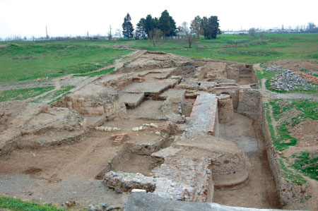
 View of the 5th excavation area
 By Tarikh Dostiyev
Studies of the remains of cities which were the focus of production and cultural and intellectual advance remain key to archaeological science. This is borne out by findings made during archaeological excavations in the city of Shamkir [in Azerbaijan’s north-west, near Ganja] as part of research into the characteristics of the process of urbanization and of city life and culture in Azerbaijan from the 8th to the 13th centuries.
First written sources
Medieval geographers grouped Shamkir with other flourishing, middle-ranking cities with resources. The 9th century historian Ahmad Al Balazuri, who recorded the history of the Arab conquests, wrote that Salman Ibn Rabiyah Al Bahili conquered an ancient city named Shamkir. Shamkir had been populous and flourishing before the Siyavurdi people destroyed it. A commander called Bugha restored the city and brought in Muslim Khazars, in the year 240 by the Hijri calendar (854/855 A.D.). He also transferred merchants from Barda and named the city Mutavakkiliya, in honour of the Arab Caliph. The attention paid by the Caliphate to Shamkir, alongside its efforts to revive city life in Shamkir was undoubtedly due to its military-strategic position and economic potential. The city was also important to intercultural dialogue, located as it was at the edge of Muslim world and on the line of contact between Islamic and Christian civilizations. Its position on the great Silk Way had made Shamkir active in international trade. Late in the 9th century and early in the 10th century, the city underwent considerable development and became a focus of handicraft and trade, as well as an important centre for the Shaddadid dynasty and, later, for the Atabey states.
The Mongol invasion in the 13th century was a disaster for Shamkir. Overcoming stubborn resistance, the invaders massacred the population and left the city in ruins.
The remains
The remains of medieval Shamkir are on the left bank of the river Shamkirchay, to the north of Mukhtariya village, at coordinates 40˚45′, 46˚07′ and 316.3 metres above sea level. The remains of fortifications, masonry from former buildings and knolls indicate a bustling city at some time in the past. Medieval Shamkir was constructed in the three sections typical of an all-Muslim city: Naringala or Ichgala (Small castle or Inner castle), Shahristan or Icharisheher (Inner city) and Rabad or Bayirsheher (Outer city). The ruined Shahristan, surrounded by defensive walls, covers a rectangular area of 28 ha, extending east to west. Naringala is east of Shahristan, on the left bank of the river Shamkirchay, rising 8.5 metres above the river, and covering an area of nearly 1 hectare. Rabad extends to the south, west, and north from the city’s castle walls, on the right bank of the river Shamkirchay.
Archaeological findings
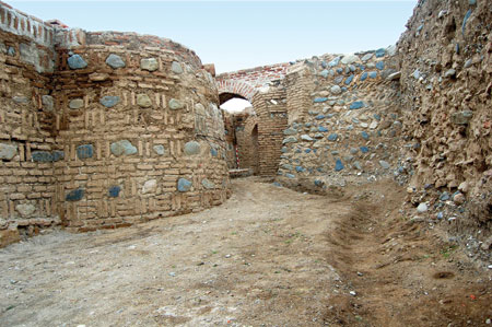 Castle walls connected by arched spans, Shamkir city
 Although the site of the ancient city attracted the attention of researchers P.C.Gamba, Frederic Dubois de Montpereux, and N.Florovsky from the early 19th century, the first archaeological excavations began only a few years ago. Large-scale standing archaeological excavations began in 2006 as a joint project of the Archaeology and Ethnography Institute of ANAS, the Ministry of Culture and Tourism and the Social Union for Regional Development. Exploration has been carried out in six areas.
Naringala
One of the main areas of research is the study of the city’s fortifications. As a result of excavations conducted in the 3rd - 5th areas in 2007-2010, remains of the north, east and south walls of Naringala (small castle), 240 metres from the base of the city walls, were studied. The dig yielded interesting information about Naringala’s plan and construction. The central and corner bastion walls were found to have been strengthened by right-angled props (counterforts). The walls are 3.5 - 4 metres wide, but 5.3 metres wide at the counterforts.
Excavation revealed that the lower layers of the castle wall were in better condition. In some parts the remains of the castle wall rise 7.5 metres from its base. The base construction varies according to local soil characteristics. At the north-east bastion, the base is on a single plane with ground level and has two stages. This form of construction increases the wall’s stability and resistance to seismic movement. There was no need for a ground layer under the central bastion because both it and its surrounding base were laid on stable gravel.
Naringala is thought to be a rare example of the Arran [old name for the area now called Azerbaijan] school of architecture. Its walls were constructed in a mixed laying style, using baked bricks, boulders, local white stone (Zayam stone) and lime mortar. Architects and masons exploited the features of local raw materials with great mastery. They gave due attention to the artistic appearance of the fortification, cladding its walls. The rhythmic alternation of white stone blocks, red brick, and grey-blue boulders both pleased the eye by creating a polychromatic wall surface, and endowed the fortification with monumentality and splendour.
Shahristan
In the 5th excavation area, an investigation of the wall of Shahristan castle was also initiated. This revealed that the wall connects to Naringala’s north-eastern bastion. There is a semicircular bastion from Shahristan in front of Naringala’s north-eastern bastion and connected to it, also a Shahristan castle wall parallel to Naringala’s north wall. A door opening in the wall, 2.9 metres above ground level, was discovered in the passage from the bastion to the wall. A three-step stairway, descending from the outside, was also found. Apparently the door was destroyed during the Mongol invasion and the invaders entered the city at this point. There were finds which brought to life the site of a great struggle with the invaders. A badly burnt layer and the many arrowheads etc. found there are evidence of those terrible times.
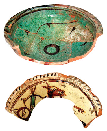 Early glazed pottery. 12th century
 While investigating the door opening, there were finds which clarified the history of the construction of this part of the Shahristan wall. They were evidence that the wall and the stairway were constructed no later than the end of the 10th century – beginning of the 11th century.
Shahristan’s castle wall stands 4.05 – 4.5 metres from Naringala’s north wall, is parallel to it for 14 metres and then turns to the north. Remains of this northern part of the wall have been found more than 60 metres distant. The wall here was strengthened with four bastions.
In the 12th century the city was defend by two parallel walls. A second defensive wall was constructed 10 metres to the west of the outer wall already described. 27.5 metres remain. Gates to the south were defended by two flanking bastions. The area between the two castle walls was cobbled. As noted above, remains of the second, inner defensive wall can be seen for 27.5 metres. In the north of the excavation area, its remains are covered by the ruins of fortifications and a street of that period, both constructed during the Mongol era. The parallel castle wall, defending Shahristan to the east, was constructed in the style of the Arran school of construction, like that of Naringala; in a mixed laying style using baked bricks, boulders, white stones and lime mortar.
Excavations conducted in a 2,000 square metre area inside Naringala, in its north-east sector, have also been successful. A layer containing evidence of cultural life, 6 metres thick in some parts, have been found here. Remains of buildings from the 19th century have been revealed in the upper cultural layer, along with tools of various function, weapons and household equipment. At the lower cultural layer, more than 4 metres thick, ruins of fortifications, other imposing structures and workshops dating from the Middle Ages have been revealed.
Archaeological excavation has begun of a significant building within the castle found in Naringala. The building’s east wall has been identified completely, while its south and north walls have been partially revealed. The east wall is 24.9 metres long and has a counterfort-like protuberance in the centre. At the eastern and southern walls, which have been studied more thoroughly, the lower layers consist of boulders and the upper part of adobe. There are areas of wood between the stone and adobe. Three doorways were detected in the eastern wall and two in the southern wall. All of them were later overlaid with adobe. Four cubic structures – columns - related to this building in the area of excavation have been unearthed and cleaned. The better-preserved column is 3.2 metres high and the walls of the complex are 3.8 metres high. The floor of the building was originally coated with plaster, but covered later with baked bricks. As the floor was cleared of dirt, many decorative fragments of alabaster were uncovered; they had once made up the building’s cornice. The fragments were engraved with elements of geometrical and other patterns, as well as with letters of the Arabic alphabet.
Domestic life
An area containing tandoor ovens, from the 9th-10th centuries and to the south of the castle, was surrounded by boulder walls. In the first area the remains of 3 ovens were found and cleared, together with a sump, once used to contain dirty water. This area was laid with flat stones and baked brick. In the north-west part of the second tandoor area, located in the south, a tandoor and the remains of a hotbed were discovered.
 Early glazed pottery. 9th-10th century
 An arched building uncovered in the 5th excavation area between the second and third bastions of the city wall, and connected to the castle wall, was constructed of boulders and baked brick with a plaster mix.
A street, residential houses, hotbeds, and tandoor ovens were revealed in the 6th excavation area in the north-east part of Shahristan. The street, extending from north-west to south-east, was covered by a layer of gravel. There were houses along the street. The ruins of an 11th century house with many rooms were found under the remains of a 12th century house.
Another street covered by gravel was also found in the 5th excavation area. The point where the castle walls of Naringala and Shahristan approached each other to form a narrow corridor, was covered with boulders and baked brick in the 11th to 12th centuries. There were interesting engineering buildings and facilities, indicating the city’s prosperity. One of the main responsibilities of the city’s state organisation was to provide the population with a constant supply of drinking water; the remains of an underground water supply line in the Rabad part of the city have been detected and studied. Another water supply facility worth mentioning is a reservoir-type spring. This was found inside a bastion in Shahristan. Constructed with baked bricks and lime mortar, it had a four-sided entrance, a 13-step stairway and an arched ceiling. Fresh air was supplied by pipes in the east wall of the spring. Water was delivered by a water pipeline from the south.
Facilities to maintain a hygienic and healthy environment have also been revealed. The purpose of an engineering structure found in the 5th excavation area was apparently to ensure the removal of rain water and melted snow, as well as the dirty water produced by economic and industrial activity. This structure represents an inclined sewer line from the city gates towards the outer walls, flowing from west to east, 43.5 – 44 cm in width and 48 – 49 cm high. It was constructed with boulders and large white stones. It takes the form of an arched construction of baked brick at the outer walls of the city. The city wall has openings for this structure. Each of the openings is 44 cm wide and 48-49 cm high. The remains of this comparatively primitive sewer line, directed towards the main sewer line, were found in the north-east area of Shahristan, in the 6th excavation area, running for 18.2 metres.
In the 10th-11th centuries, at the point where the walls of Naringala and Shahristan are close to each other, rain water collecting in the street was removed by a four-sided opening in the city wall. Cobbling the street raised its level, thus a drainage line was constructed from white stone and baked brick to remove rain water. The drainage line was covered with flat white stones and an opening was made in the wall.
Remains of a sewer line were also detected inside Naringala. The line is dated to the 9th-10th centuries and was constructed from baked brick, boulders and plates of flat white stone.
Craft and culture
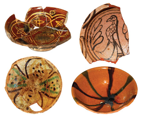
Medieval Shamkir was one of the main art and trade centres in Arran. Interesting materials were found during the archaeological excavations concerning the production of metal artefacts, arms, pottery, glass etc. The finds include tools, armaments and household goods, as well as construction and production tools, copper and bronze objects, artistic stone artefacts, and coins. Artistic tools are represented by an axe, hammer, adze and pencil. Multifunctional knives are common among household tools. Daggers, fighting knives and swords represent close combat weapons. Armour was also found. Glazed and pottery products are very common. Pottery products are identified as being for storage and other business, kitchen and table plates, lighting purposes, crockery for hygiene, and other special-purpose crockery. The vast majority of pottery products were made on a potter’s wheel and baked at constant temperature; it is dense and red-pink in colour.
 Pottery ware. 8th-9th and 11th-12th centuries
 Pottery products, mainly table plates, display the craftsmen’s exquisite taste and creative abilities. Pottery painters created rare works of art in bright colours, using motifs taken from geometry, flora and fauna. Most early pottery tableware is crockery, decorated with engobes and manganese, with a transparent glaze. Fluted monochrome plates also stand out among the early pottery products. Crockery with polychrome surfaces is particularly widespread. Geometric and nabati (floral) patterns are used in decoration, together with images of animals and birds. Sometimes, images with a storyline – hunting or fight scenes, can be found on plates. Other finds prove the local production of faience. Scratched and drilled lines, stroking and engraving methods, geometrical and nabati patterns, white and milky colours, and blue and turquoise coatings were used. Along with local faience tableware, golden patterns were also widely used. This kind of tableware was produced in the cities of Rey and Kashan. The finds are evidence of the wide use of elegant glass dishes in everyday life, as well as of the production and application of window glass in the city from the 11th century. Personal adornments were made for head, neck, chest, hands and arms as well as for clothing. They were made of copper, bronze, gold, silver, glass, bones and precious stones. Most coins are of copper. The oldest date from the 7th-8th centuries. Coins minted by the Atabeys government are the most commonly found. Numismatic evidence proves the existence of a mint in the city of Shamkir. Among the coins found are golden ones minted by Byzantium in the 11th century and silver ones minted by the Abbasi Caliphs. Of the epigraphs uncovered, an inscription engraved on alabaster on baked brick is most significant. The words “…power belongs to Allah…” are written in the Kufic-style inscription.
An important area of work for the Shamkir archaeological encyclopaedia is the preservation of buildings revealed during archaeological excavation which are in danger of disintegration. Preservation work is carried out using construction materials such as boulders, baked brick and white stones found during archaeological excavation. Adhesive materials are made as close as possible to the medieval materials.
In all, the study of medieval Shamkir has provided significant evidence and opportunities for researchers in the process of reconstructing medieval city life in Azerbaijan, as well as information about the architecture, art of war, economy, culture and everyday lives of our cities in the 8th-13th centuries.
About the author: Tarikh Meyrut oglu Dostiyev is a Doctor of Historical Sciences and head of the department of Archaeology and Ethnography Institute of the Azerbaijani National Academy of Sciences. He is also head of the Shamkir Archaeological Encyclopaedia.