 Nestled in the southern foothills of the Caucasus Mountains lies the tiny village of Chukhur. This is Qabala, a region known for its extraordinary natural beauty. Who would guess that very close to this sylvan paradise lie the remains of an important ancient city of the same name?
There is evidence of this city in very early historical writings. Pliny the Elder mentioned Qabala in his encyclopaedic first century work Natural History. Pliny calls the city Cabalaca and describes it as the main oppidium of Albania (praevalent oppida Albaniae Cabalaca). (P1. NH, V, 29). Oppidium is the Roman term for ancient fortified settlements throughout Europe. It is clear from Pliny’s writings that he was aware of the existence of other Albanian towns besides Qabala. Indeed, a bit later, in the second century A.D., the Greek geographer Claudius Ptolemy listed the names of 29 towns and other large dwellings of Albania in his work entitled Geography. Among them is the name of Qabala, spelled as Khabala (Ptol. V, II, 2). Later still, many medieval sources in various languages provide information about Qabala and its importance in the history of Azerbaijan.
However, these ancient sources cannot give us a detailed and accurate picture of the ancient city of Qabala. For this, serious archaeological excavations are needed and Qabala has a fairly long history of archaeological digs, dating from as early as 1830. In 1829, a Russian researched named A. Yanovsky visited Qabala and initiated explorations. He wrote later that the ruins were of the same Qabala that is mentioned in the ancient sources. After this initial foray, work did not resume until 1926 and then again from 1944-45.
Serious modern excavation of the site started in 1959 and continued until 1990. Work resumed on a much larger scale in 2005 with financial assistance from the SEBA (Seoul-Baku) Azerbaijan-Korean Cultural Exchange Association. Archaeological excavations are now carried out every year.
Two and a half millennia ago…
On the basis of this work and the ancient sources, we know that the town of Qabala was founded in the 4th century B.C. and survived until the 18th century A.D., a total of about 2,200 years. This settlement was the capital city of Caucasus Albania, the ancient Azerbaijani state, for a period of 800 years until the 5th century A.D. It then grew into an important administrative, economic and cultural centre. Over this long period the town was sometimes forced by historical events to shift its location. Thus, some of the settlements were eventually turned over to agricultural cultivation and pasture.
At present, the ruins of ancient Qabala are located in three areas. The original site existed from the 4th century B.C. to the 1st century A.D., some 400 years. It was located on the left bank of the Garachay River. The territory covers 50 hectares and was used for cultivation for a millennium. The remains of large buildings were detected from observations of contours and other indications. Small hills cover the area of the buildings and thus distinguish the site from the surrounding area.
In planning the fortified town, the builders used natural features to help with defence. The town is protected by the steep rocky bank of the Garachay River on the western side. Deep valleys run along the north-western side and a wide valley covers the east. There is running water from the eastern side and an earth barrier of 1,200 metres is still preserved along the southern side. A deep, wide moat ran outside this barrier or rampart. Some of this 3 metre high defensive wall still remains in places. It was 8 metres wide at the base and 6 metres wide at the top.
Relocation 1
At the end of the 1st century A.D. there were big changes to life in Qabala. In order to avoid attack by invaders the town, which had existed for 400 years, was abandoned and the populace shifted to a location more suitable for strategic defence. This catastrophic event was probably the result of attacks by nomadic people from the North around the year 70 A.D.
There was great destruction during the displacement. There is evidence of fires having raged. It appears that the remains of some buildings were taken down and used for construction in the new territory.
The new site was located to the north-west, approximately 2 kilometres from the original town. It perched on a high plateau along a north-south axis between the rivers Garachay and Jovurlu. The plateau stands 20 metres above the surrounding territory. While planning the new town, the builders made clever use of natural conditions to construct an even more impressive fortification than before. The foundations of the defensive walls were constructed from river stones and the top was built with bricks. Beyond the walls and the plateau, the whole territory was surrounded by a moat. In addition, natural valleys were used to further protect the settlement.
During the 5th and 6th centuries, the defense walls were strengthened and improved several times, then once again in the 9th century. A gate place, with great walls and towers built of stones and burnt bricks, was built on the southern side at this time.
Relocation 2
At the end of the 10th century, catastrophe struck once again. The population of the town declined sharply and it became difficult to defend the entire territory, so the remaining population moved to the southern part of the town. The northern part of the town (half of the whole territory) was now named Salbir. It was separated from the southern half, called Gala, by a deep, wide moat.
The name Salbir is connected with the name of the Savir-Sabir tribe of Huns who were part of a confederation of Khazar tribes. According to Arabian sources of the 9th century, Khosrov Anushirva (531-579 A.D.) belonged to the Sassanid dynasty (3rd to 6th centuries) of Iran. He settled about 10,000 people, who had been captured during battles with the Khazar tribes, in Qabala and the surrounding area. This is why, the 10th century author Balazuzi referred to Qabala as Khazar. Artefacts connected with the Khazars have been discovered in excavations of the Salbir area. It is interesting that the end of habitation in the Salbir area coincides with the period of the defeat of the Khazar Khanate. Archaeological excavations of the town have revealed information about all stages of development in the town life of Qabala.
Digging down the ages
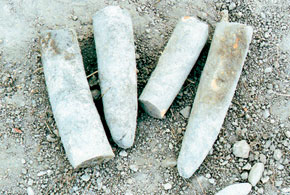
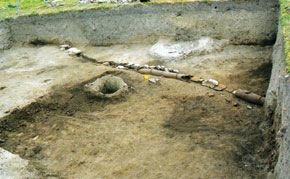
Excavation of the site of early ancient Qabala began in 1967. The southern defensive walls and the area of the town gate were investigated. There were also extensive excavations on the town itself. The remains of a large public building were discovered in the first excavation area. The walls of this building were constructed of bricks and reached a height of 2.1 metres. There were large halls, vestibules and other comparatively smaller rooms. Inside each large hall there were two monolithic column bases. The columns themselves were made of wood. The inner floor area of this building measures 590 square metres. The roof was covered with large, flat gutter-shaped tiles. This building belonged to the 1st century B.C. to 1st century A.D. and appeared to have had an administrative function.
The remains of various buildings were discovered in the lower layers of the town, dating from the 4th to 2nd centuries B.C. Here too, the roofs of some buildings were covered with high-quality tiles. The excavations carried out here showed that tiles have been used for covering roofs in Qabala since the 3rd century B.C. The tiles used in Albania indicate Greek influence and the presence of a high urban culture.
The remains of three large buildings set out in oval form have been discovered in the 3rd excavation area. This discovery has attracted a great deal of interest. The inner floor area of one of the buildings measures 1,400 square metres. The foundations of the walls are 1.8 metres thick and were constructed with river stones. The walls were built with bricks. The inner length is 71 metres and they are 19.5 metres wide. There was a 2.2 metre wide river stone pavement along the walls. Inside were 11 columns in the central area along the full length of the building. Two wide doors opened in the eastern wall and another door of the same size was fitted in the western wall. There appears to have been a special place for a guard next to one of the doors in the eastern wall. It seems that only persons with special permission were allowed to enter.
Two other similar buildings were found in this area. They were smaller than the first one. They belong to more ancient times, the 3rd to 2nd centuries B.C. No other buildings of this type have been discovered anywhere else in the Caucasus or the Near or Middle East. With their oval form, these buildings resemble the hippodromes of Ancient Greece and the amphitheatres of Ancient Rome. They were probably used for religious ceremonials, administrative meetings, or special performances.
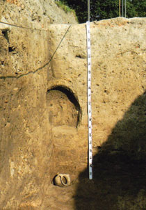
The remains of a large food storehouse were also discovered recently in the layer of the town belonging to the 4th to 3rd centuries B.C. Not all of this area has been excavated. Various foodstuffs in big earthenware pitchers were buried in the earth in rows. The remains of approximately 240 earthenware pitchers for household use have been revealed so far. Palynological investigations of samples taken from inside the pitchers revealed that they held wine, grains, walnuts, hazelnuts and other produce.
There were ten tons of foodstuffs in the storehouse. It is impossible that such a large amount belonged to one household. It probably had urban or even a state significance. Discovering such a storehouse from this period is an exceptionally rare event.
Alexander, Caesar,Tamerlane
Also discovered were various work tools, pottery, earthenware objects with various seals (bullas), local silver coins and foreign coins. A gold coin and other household items belonging to the Hellenistic period were found in excavations of the town site. Weapons, a bronze helmet and many earthenware pots and decorative items were also found in tombs near the town.
The site is rich in monetary treasures from ancient times. One item found in 1966 belonged to a 20 to 30 year period of the 2nd century B.C. There were more than 500 local Albanian silver coins, along with silver tetradrachmas and drachmas issued by Alexander the Great, Lysimachus the King of Thrace, the Seleucid Empire, Greece and Parthia. Other treasures belonged to the 3rd century and consisted of money from Parthia, the Roman Empire and Sassanid ruler Varahra II (276-293). Silver denari from Julius Caesar were also revealed during excavations of the town.
Two thousand years ago Strabo wrote that trade in Albania was carried out by exchange. Thus there was a belief that Albanians did not use money. However, large hoards of currency found in the town and tombs prove that Albanians were trading with locally-minted silver coins as well as coins brought from other countries 300 years before Strabo. Albanian currency was assimilated into that of Alexander the Great. These coins were probably minted in Qabala, the capital city of the state. In ancient times Qabala maintained trade relations with all its neighbours and with some far distant countries. The remains of public and residential buildings and handicraft workshops, samples of thousands of different earthenware and glass utensils and weapons, decorative items and hundreds of local and foreign coins have been discovered.
The Muslim Renaissance was clearly felt in Qabala. The site of the Southern gate in the Gala area of the town, with its magnificent defensive walls and towers built of calcareous bricks indicate a highly developed town culture in Qabala in the 9th century. Handicrafts and trade were highly developed in Qabala in the Middle Ages. At the end of the 14th century, even the advance of Timur (or Tamerlane, 1370-1405) did not expose Qabala to great destruction. This is proved by archaeological excavation as well as by a famous poem dedicated to the town by Badr Shirvani (1387-1450), who visited Qabala soon after Timur’s passing. The poet described Qabala then as a flourishing town.
Qabala declined in importance only in the middle of the 18th century. The present Chukhur Qabala village near the town ruins has preserved the name of an ancient town which existed for more than 2,000 years. The archaeological excavations carried out there enable us to study deeply and comprehensively the medieval period of the Albania state as it existed from the 4th century B.C. to the 7th century A.D.
There are many fascinating historical secrets still to be revealed in the ruins of Qabala and excavations continue. The site fully deserves to be included in UNESCO’s listings as a historical monument of world significance!
Literature
1. Material culture of Azerbaijan. Volume 5, Baku, 1964
2. I.A.Babayev, G.M.Ahmadov, Qabala (historical and archaeological essay). Baku, 1981
3. I.Aliyev, F. Gadirov, Qabala, Baku, 1985
4. I. Babayev Excavations of Communal buildings (Fourth Century B.C. – First century A.D.) at Qabala, the Capital of Caucasian Albania, The Royal Palaca Institution in the First Millenium B.C. Monographs of the Danish Institute at Athens, Vol.4, 2001
5. I.A.Babayev, Towns of Caucasian Albania from the 4th Century B.C. to the 3rd Century A.D., Baku, 1990
6. I.A.Babayev, Monetary Circulation in Caucasian Albania during the Hellenistic Era (End of the 4th century – First Half of the 1st century B.C.)// Works of the Azerbaijan History Museum, Baku, 2002
7. Historical questions of Caucasian Albania. Baku, 1962
8. V.G.Lukonin, A.Rajabli, Treasure of Chikhur-Kabala. Appendix in the book: V.G.Lukonin, Iran in the 3rd century. М., 1979
About the author: Professor Ilyas Babayev is a head of department in the Institute of Archaeology and Ethnography of the Azerbaijan National Academy of Sciences (ANAS), a corresponding member of ANAS and doctor of historical sciences. He is well-known in Azerbaijan as an archaeologist and is the author of many monographs and articles about Caucasian Albania, including the archaeology of Qabala.
